The ancient Mayans built a civilization that spanned more than two thousand years. They settled and developed communities across a vast area, nowadays occupied by Belize, Honduras, and Southern Mexico. They flourished most notably in the lowland region of the Yucatan peninsula, along the southern coast of the Pacific, an area now known as the Riviera Maya. There, they built thriving cities, and established trade routes.
The Maya people were an amazingly advanced society – they were expert engineers, builders, mathematicians, master stone workers, creative artists, and chroniclers. They were also well versed in astronomy, and developed a precise calendar based on the movements of the sun, moon and the planets (they calculated it as far as 2012 – thankfully, the world wasn’t destined to end yet!).
In stark contrast with these civilized accomplishments, their religion and worship of the Feathered Serpent God Kukulcan (Quetzalcoatl among the Aztecs) required regular human sacrifices, they captured slaves and exploited them mercilessly as a disposable workforce, and played sports – notably ball games – which were so violent that the death of players was common.
The Maya built towns which, at their peak, were home to tens of thousands of people, and from these they conducted international trade. Since around 1000 BC, they have left their mark on the Riviera Maya region, and the astonishing vestiges of their momentous cities, with their towering pyramids and fortified walls, remain dotted along the coast and hinterland, for the greater joy and wonder of visitors.
Here are the Mayan ruins of the Mexican Riviera Maya you shouldn’t miss!

Chichen Itza
Located 75 miles south east of the city of Merida, in Yucatan state, Chichen Itza was one of the largest Mayan cities ever built, and was so awe-inspiring that it achieved almost mythical status. It became hugely influential in politics and trade from around 600 to 1200 CE.
The Itza tribe most likely chose this site to settle because of its sinkholes, or cenotes, which provided drinking water in an otherwise arid region. There are in fact two of these within the Chichen Itza complex itself – these may explain its name, “at the mouth of the well of Itza”.
The city was home to 35,000 people at its peak, at which time it was major trade hub, sourcing obsidian (a volcanic glass-like rock) and gold from central Mexico for export. It also became a military power, and a center of religious worship, as is shown by the ornately decorated temples within the complex.

The most spectacular building in Chichen Itza is undeniably its pyramid, often referred to as ‘El Castillo’, the castle. Its other name, the Temple of Kukulkan (the Feathered Serpent God), is perhaps more relevant, since it describes the pyramid’s ancient function. The edifice recently acquired the title of one of the Seven New Wonders of the World, but wondersome or not, climbing it is forbidden.
The Chichen Itza site is big, and has many other noteworthy buildings. Its ball court – 545 feet long and 223 wide – is the largest of its kind ever found. The aim of the game it was used for, was to pass a ball through vertical hoops on the walls. Grim murals here depicting victorious players holding the severed heads of losers, indicate the brutality – and stakes! – of the game!
The Thousand Columns is a group of columns like stone trees, which look a bit like a playground labyrinth! In fact, they used to support the upper floor of a stately building. The Temple of Warriors, with its relief images of warriors, eagles and jaguars eating human hearts, suggests Mayan soldiers were not to be trifled with! Also worth seeing at Chichen Itza are the tomb of the High Priest, and the ‘Nunnery”, so named because its large number of rooms suggest it was once home to priestesses.
Chichen Itza attracts 2.5 million visitors a year, and was declared UNESCO World Heritage in 1988.

Tulum
A 45-minute drive south of Playa del Carmen, or 90 minutes from Cancun, the ruins of Tulum are located in the heart of the Riviera Maya, and are the only cliff top archaeological complex in Mexico. Their Mayan name, Zama, translates as “place of the dawning sun”, and from this vantage point, high above a turquoise sea and a white sand beach, the rising sun – which Tulum faces – is indeed spectacular.
Tulum is one of the best-preserved coastal Mayan sites. Much smaller than Chichen Itza, it is no less popular, with up to 2 million visitors a year. Tulum’s “El Castillo”, a beautiful stone tower, is perched atop the highest point, and formerly served both as a watch tower for this little settlement – which was home to less than 2000 people even at its peak – and as a light house. A thick coral reef out at sea blocks access to the shore, and with only a narrow breach through which ships could safely pass, they would use the tower to guide them.
The city was one of the last to be built and inhabited by the Mayans before the arrival of the Spanish conquistadors. It was an important trade hub between the 13th and 15th centuries, and commodities such as obsidian, turquoise, cotton, copper bells, axes, cacao beans and other foods were shipped from it.
Tulum was a fortified sea port – while cliffs protected the site from the east, strong stone walls surrounded it in other directions. It was also a religious town, where the enigmatic Great Descending God was worshipped – and whose images are still visible in the Tulum complex temples.

The site today is well maintained, with smooth lawns between buildings – and a large number of iguanas who like to bask on the warm stones! Aside from the tower, and the remaining sections of wall, the two other buildings to see are the Temple of Frescoes, and the Temple of the Descending God. The frescoes on the former still bear traces of color, and depict snakes, deities, and flowers. The Descending God was the major deity in Tulum, and in the single room temple, he is shown with wings and a ceremonial headdress.
Visitors should bring swim wear – a dip in the sea at the small beach below the ruins is included in the entrance fee!
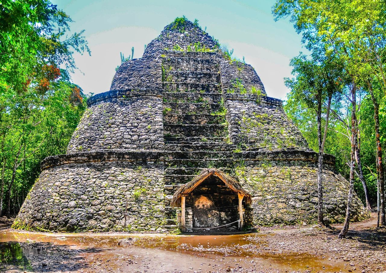
Coba
The ruins of Coba, in Quintana Roo state, lie 30 miles northwest of the town of Tulum. By car, they’re an hour and a half from Playa del Carmen, and a little over two from Cancun. Spread over 30 square miles, with the 4 in the middle open to the public, Coba is surrounded by dense jungle. In the Mayan language the name means “ruffled waters”, or “waters stirred by the wind”. The name stems, no doubt, from the two lagoons (which would have provided water), around which the city is built – Coba lagoon, as you approach the complex entrance, and Macanxoc inside. A sizeable agricultural population had settled at Coba as early as the 1st century CE, and at its height between 600 and 900 CE, Coba was a bustling metropolis of up to 50,000 people. The city then slowly declined, and was abandoned with the arrival of the Spanish.
Coba was only opened to the public in 1973. Archaeologists had known about the site since the mid-1800s, but the impenetrable jungle made it very difficult to access. Traveling there was made dangerous by the Caste War, a prolonged and brutal insurgency on the part of native Mayan people, against Hispanic settlers who were increasingly taking over their land.
When archaeologists finally did make it to Coba, they found a city unlike any other. The site showed entire settlements, all distinct and separate, connected to a central pyramid by 16 white roads. The site as a whole has some 50 of these white stone roads, called sacbes, which form the largest network of stone causeways anywhere in the ancient Mayan world.
120 steps take visitors to the summit of Nohoch Mul pyramid, and from 137 feet above the ground, visitors can take in views of the jungle around, and the lagoons below. The pyramid is one of a number of structures at Coba that can be climbed. Close to the entrance is the Coba group, a cluster of buildings including a church, or place of worship, and the ubiquitous ball court. A sacbes leads to the Macanxoc group, by the lagoon, which has 8 stelae and a number of altars. Stelae, which are large slabs of standing stone, are particularly precious as keys to unlock the past – the ones in Coba are inscribed with pictures and glyphs that document past events and facts. Their engravings also show that women played a prominent role in society.
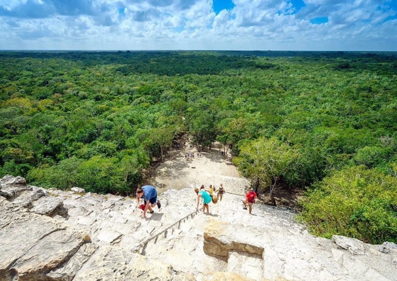
Coba is a wonderful excursion into nature, as well as a journey into the past. It is also quieter and less visited than other sites. You can tour the site in one of three ways: on foot, in a bicycle taxi (naturally fully air-conditioned!) or by renting a bicycle of your own.
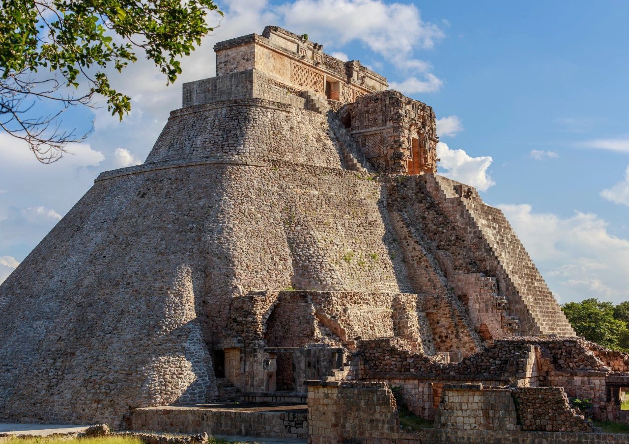
Uxmal
Uxmal is a breathtaking UNESCO World Heritage site, situated ear the city of Merida, in the low hills of north-west Yucatan. Although it’s a full four-hour drive from Cancun, the 150-acre archaeological park is the second most visited in Mexico. An important Mayan city, at the height of its glory between the 6th and 10th centuries CE it was home to at least 15,000 people, and perhaps even double that figure. Uxmal is on the Ruta Puuc, a trade and transport route connecting a number of Mayan cities.

Uxmal benefitted from an extensive restoration program making it the best preserved of all Mayan sites. Its World Heritage status, acquired in 1996, recognizes the layout and esthetics of the ruins as being the very pinnacle of late Mayan art.
And indeed, in terms of artistic skill and engineering prowess, the people of Uxmal seem to have been in a class of their own. Their stone masonry and carved stone art is the finest of all ancient Maya sites. Their building skills were unrivalled too – in a dry land, Uxmal managed to store water for its inhabitants by constructing astonishing storage tanks which could cumulatively hold up to 5 million cubic meters of water. That’s the amount of water in 200 Olympic swimming pools!
The first building that beckons the visitor is the 131 feet-high Pyramid of the Magician. The name Uxmal actually means, “thrice built”, a reference to the many layers of construction the edifice required. To avoid damaging, climbing the Pyramid of the Magician is not allowed.
The Great Pyramid, however, you can, and should, ascend! Its steps take you up nine levels to the Temple of Guacamayas, with its decorative carvings of the rain deity, Chac. The governor’s palace, a long, low building on a raised platform, is the Mayan version of an administrative block – but one for high officials, with an ornate façade dedicated to the planet Venus. The buildings that form the Nunnery Quadrangle, meanwhile, suggest a hierarchy of inhabitants, most likely priestesses at various stages in their training. All around the site are beautiful effigies of animals – turtles, doves, and other birds – indicative of the Mayans’ close connection to the natural world. And, of course, there’s a large ball court!

Ek Balam
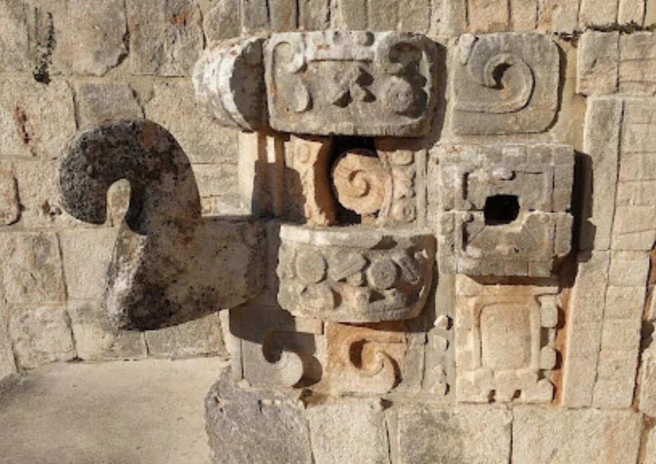
Ek Balam, meaning “Black Jaguar”, lies some 17 miles north of Valladolid city in Yucatan state, 35 miles north east of its sister city, Chichen Itza, and a little over 100 miles from Cancun. The city ruled over an entire Mayan kingdom, though the peak of its splendor was quite short-lived, and lasted only from around 770 to 840 CE. Ek Balam is architecturally unique in that most of its decorative carvings and statues were not cut from stone, but rather molded from stucco, a mixture of plaster, water and a binding agent.
Nevertheless, Ek Balam’s history began around 100 BC, and the city was inhabited for a thousand years. Although only the central part of the site has been fully excavated, no less than two outer fortifying walls have been revealed, as well as several more within the city.
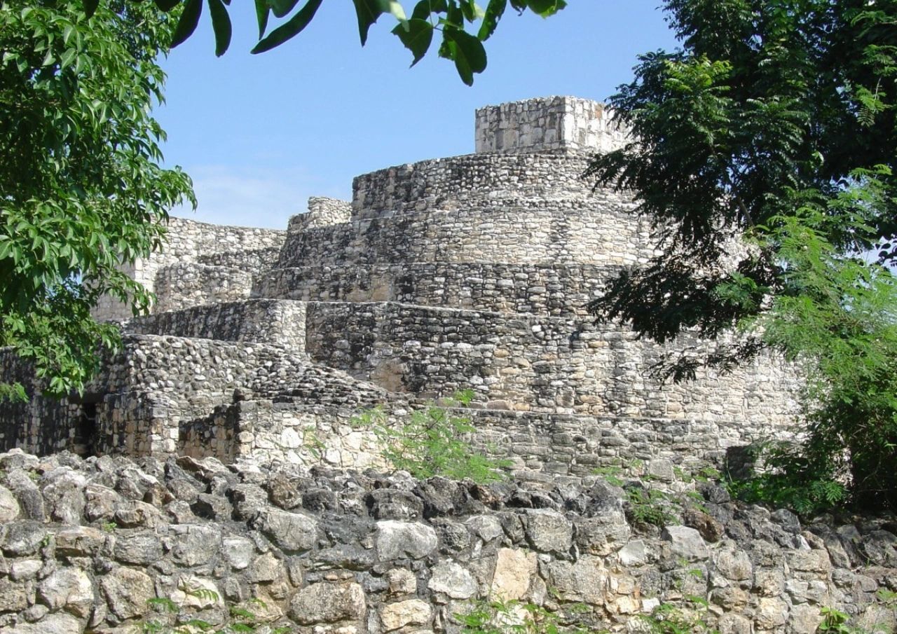
A great way to start your visit to Ek Balam is to climb the Palacio Oval near the entrance. This will give you a nice view over the rest of the site, and give you a glimpse of what awaits you! You may want to head straight for the main attraction, the Acropolis. After climbing to its summit, 100 feet up, you’ll have a broad and stunning view over much of the Yucatan peninsula.
But the Acropolis is not, in fact, a pyramid. It is a multi-purpose building which housed both the living and the dead. Or at least, one dead person! Some way up the structure is the tomb of the revered 8th century ruler Ukil-Kan-Lek-Tok. The entrance to the tomb is shaped like the huge mouth of a jaguar – though some see it rather as a guardian deity of the underworld. Officials of various ranks, and nobles, would have lived in the 6 levels the Acropolis houses.

Los Megelos is a more gruesome structure – two identical buildings atop a raised platform, which was most likely used for human sacrifices. And since the Mayans did love ball games…you guessed it, there’s a ball court!
A nice way to end the visit is to swim in the X’Canché sinkhole. From the site of the ruins, you can rent a bicycle, and take yourself to it, for a swim in beautiful, blue waters
Ancient history can seem quite abstract, or the stuff of movies and TV shows. But when you visit the Riviera Maya ruins, it seems very real! At the foot of towering pyramids, on ball courts the size of a small stadium, or surrounded by carvings bringing creatures and people of the past alive, you feel transported back in time.
There’s also so much more to do on the Riviera Maya! Between your forays into the past, you could go diving near the world’s second largest reef, head off to adventure parks or on nature treks, enjoy great beaches, fine dining, do yoga, go dancing or rock-climbing, or visit a natural park!
—
If you feel the pull of the ancient Mayan world, and would like to experience more Riviera Maya fun, don’t hesitate to contact us and find out about Mexico travel options!